The Uinta Highline Trail is a 104-mile-long trail that traverses the Uinta Mountains in northern Utah. The western two-thirds of the trail is within the High Uintas Wilderness and alternates between ascending high mountain passes and wandering through flat, open expanses of alpine tundra dotted with lakes and streams. The eastern third of the trail is drier and more heavily forested as the route slowly ascends the gentle eastern slopes up to the high country. The trail crosses 8 alpine passes and comes within a mile of Kings Peak (13,528’), Utah’s highest peak.
A subrange of the Rocky Mountains, the Uintas are unusual for running east to west instead of north to south, one of the few major North American ranges to do so. They contain all of Utah’s peaks above 13,000’ in elevation. In general, the range looks and feels gentler than the sky-rending peaks of other popular U.S. mountain ranges such as California’s Sierra Nevada and Wyoming’s Teton Range. However, because the trail lies almost entirely above 10,000’ and ascends several passes above 12,000’, there are still many difficult climbs and many spectacular views.
The trail remains more rugged than many other long-distance trails, partly due to its lower popularity, but also partly due to the intentional decision to not maintain large stretches of trail, instead marking the path through meadows or across basins with massive cairns (stacks of rock made by hikers to mark the way). This gives the trail a unique wilderness character that is sometimes lacking from more obvious trails and makes it more akin to a cross-country route rather than a trail at times. For this reason, navigation is more important on the High Uinta Trail, however there is almost always at least one trail marker visible, and the terrain is flat enough that it is rare to need to make decisions beyond “walk to the next cairn”.
I hiked the Uinta Highline Trail from east to west from September 1st 2023 – September 8th 2023, starting at McKee Draw along Highway 191 and ending at Hayden Pass along the Mirror Lake Highway some 50 miles east of Salt Lake City. This served as my main backpacking trip for the summer of 2023. While not as long as my adventures on the Pacific Crest Trail in 2022 or the John Muir Trail in 2024, I have fond memories of this trip due to the pristine solitude, diverse wildlife, and beautiful basins and lakes, along with a few navigation and weather challenges that required situational awareness.
Trip Statistics
Starting Location: McKee Draw, U.S. Highway 191
Ending Location: Hayden Pass, Mirror Lake Highway
Length: 104.6 miles
Duration: 8 days
Average Mileage per Day: 13.1 miles
Longest Day: 16.7 miles
Elevation Gain: 18,611’
Elevation Loss: 16,469’
Resupply Stops: 0
Transportation
The west terminus of the Uinta Highline Trail at Hayden Pass is fairly easily accessible from Salt Lake City area, being only a 3-hour drive from SLC airport. Rather than flying in, I drove directly to the trailhead from Southern California, which took about 11 hours. I camped at Trial Lake Campground the night before starting my hike, as it was very close to the trailhead.
Transportation to the east trailheads is much more complicated. The eastern end of the Uintas are remote with no major cities nearby. The best option is to leave a car at the ending trailhead and take a commercial shuttle around the entire mountain range to the starting trailhead. A shuttle from Hayden Pass to McKee Draw south of Flaming Gorge takes 3-4 hours and can cost $150+ per hiker. There are several shuttle options available, but I chose to go with Mountain Trails Transport. This shuttle service was very professional and punctual, and the owners and drivers were highly knowledgeable about the trail and the area. The owner even shared intel on the status of an unreliable water source in the first 20 miles of the trail from other thru-hikers and the owner’s own hikes in the area. This intel turned what could have been a potential 20-mile water carry at the start of the hike to only a 12-mile water carry.
Day 1 – McKee Draw to Manila Park
Mile 0.0 – 12.2
My UHT journey began at about 12:30pm from McKee Draw. McKee Draw is a large open meadow, so the trail was initially flat, but as soon as it entered the trees it started climbing fairly steeply. The first 4 or so miles to East Park Reservoir were mostly on an ATV trail, which was rocky in places but generally easy to follow. The weather held out for the morning and early afternoon, but as soon as I got to East Park Reservoir, a sudden storm pelted me with a short but intense shower of rain with some hail mixed in. The storm retreated as fast as it arrived, and within 10 minutes the rain had stopped and the sun had begun to shine through. An early reminder that this was a late-season hike and I would need to pay attention to weather more closely than normal.
After filling up with water at the reservoir, I set off back into the forest before the rain had a chance to start again (thankfully, the remainder of the day was overcast but free of rain). The trail took on a far more primitive feel after East Park Reservoir. The tread alternated between fairly obvious trail through thick forested sections; rocky, lightly forested sections where the trail was hard to see and primarily marked with cairns and dilapidated signs; and open meadows where the trail disappeared entirely save for a few rock piles and signs on the forest edge indicating where the trail stopped and started. In places, I felt that I was the first person to walk this way in years, though there were signs of the trail being upkept, such as logs being chopped up and moved off the trail. While the poor tread and vague, overgrown sections made navigation difficult, causing me to lose the trail 2-3 times, it was generally fairly obvious when I was no longer on the trail as forward progress became much harder. Liberal use of my phone’s GPS app here was helpful to keep on track.
I arrived at Manila Park (a large open meadow area) around 7pm and was able to locate a spring thanks to the detailed directions of the shuttle service owner. Setting up camp near the spring, I enjoyed the first night with water security that would have otherwise been difficult to come by in this dry section of the Uintas.


Day 2 – Manila Park to Lake Wilde
Mile 12.2 – 29.0
The morning started out cold, overcast, and lightly raining. I waited 30 minutes until the rain stopped before taking down camp. The cold, overcast weather would continue until noon, when the sun broke through occasionally to warm up the mountains. It thankfully did not rain much today after breaking camp.
Throughout the remainder of the lower Uintas, the tread of the trail continued to be questionable at the best of times, and non-existent save for cairns in many places. This slowed down my pace a bit – whereas I can usually walk about 2 miles per hour with a backpack on well-maintained trail, here I was walking about 1.5 miles per hour due to the rocky terrain and pathfinding. Where there was alpine tundra and meadows, this pseudo-offtrail travel was easier to navigate, but where there was dense forest, getting lost became much easier.
Still, the terrain itself was not difficult. Most of the day was spent going up and down rolling hills. At around 3pm, I arrived at Leidy Peak Trailhead. From here the trail circumnavigates Leidy Peak, the easternmost peak in the Uintas above 12,000 feet. I had considered ascending the large, rounded massif that is Leidy Peak, but decided against doing so when seeing the steep corniced snowbanks near the top of the peak.
The views really opened up for the first time at Leidy Peak. While traversing the peak, the trail left the dense forest behind, granting grand, open panoramas of the nearby basin and mountains. The Leidy Peak area also saw the end of the eastern Uinta water drought, as many small streams flowed from its slopes.
After passing to the west side of Leidy Peak, I set up camp at Lake Wilde, a small lake directly below Gabbro Pass, the first pass along the Uinta Highline Trail. A small snowfield hung below the pass – navigating around this snowfield would pose yet another minor navigational challenge to start off Day 3 of this trip.


Day 3 – Lake Wilde to Chepeta Lake
Mile 29.0 – 38.1
I awoke to heavy rain pelleting the side of my tent. This rain, accompanied by winds and fog that limited visibility to only a couple hundred feet, would continue for several hours and delayed my start over Gabbro Pass. I decided to hunker down in my tent and wait for the rain to slow and the fog to clear a bit since I wasn’t planning on hiking too far today anyway. In the meantime, I let my emergency contact know the cause of the delay over my satellite beacon.
At around 9:30am, the rain stopped and the fog started to ease up. I took the opportunity to quickly pack up my tent and started up the pass at 10am. The trail up the east side of Gabbro Pass was fairly well defined and easy to follow. However, the snowfield 2/3 of the way up the pass covered the trail and blocked easy access to the top. The snow was too steep to comfortably walk on without traction such as crampons. I chose to climb around the side of the snowfield on a steep but solid talus slope. The bypass of the snowfield was slow but relatively short – I only had to climb up about 50 feet to get to the top of the snow layer.
For the next 4 hours, there was light rain and thick fog that obscured any views and cut visibility significantly. This was a minor problem since most of the trail above treeline was alpine tundra marked by cairns, and navigation was sometimes difficult if the fog blocked the next cairn.
While filling up water at Deadman Lake, I met Bryan, a fellow hiker from the shuttle who started the trail at the same time as me. Bryan hiked a bit slower than me, but I tend to take longer breaks, so we ended up leapfrogging most of the day. While climbing the hill after Deadman Lake, Bryan was in front of me by about 300 feet, and the fog was just thick enough that I could barely see his silhouette. It was a bit ominous to see a figure moving in and out of the edge of view.
Eventually, the weather cleared up a bit and the sun showed its face occasionally. The trail passed Whiterocks Lake, meandered through some marshy meadows and forest, and arrived at Chepeta Lake trailhead. Along the way, we spotted a moose in one of the small meadows. Surprise wildlife sightings like this never fail to make the rain and cold worth it!
Bryan and I decided to camp at the far end of Chepeta Lake (actually a small reservoir), as it was a good low elevation location sheltered from any inclement weather. It also set us up for tomorrow to climb up to North Pole Pass, the first pass above 12,000’ of elevation.


Day 4 – Chepeta Lake to Kidney Lakes
Mile 38.1 – 52.0
Today my newfound companion Bryan and I experienced a harrowing winter adventure as we climbed up and over North Pole Pass. The forecast for today – which we were able to pull up on our InReach satellite beacons – predicted light snow in the morning that would clear up in the afternoon. It lightly snowed in the morning before we left camp, blanketing our tents and the surrounding hills in a thin white dusting. This was just a prelude to the weather on top of the pass, though.
North Pole Pass, at 12,200’ of elevation, is one of the most exposed passes along the UHT. We thought that the main danger of ascending the pass today was going to be thunderstorms, but snow on the trail would certainly complicate things as well. We cautiously started the 2,000’ ascent from Chepeta Lake at 9:30am. At first, we thought we had a clearing in the snow as the sun poked through the clouds. In fact, the snow cover made the surrounding hillsides and valleys incredibly beautiful.
About two-thirds of the way up the pass, though, the snow returned in force. The ground was already coated in 2-3 inches of snow, and the new storm added even more. These were not blizzard conditions, but the rate of snowfall quickly obscured the tracks going up the pass. Most of the climb went smoothly despite the snow, with each of us only slipping once, but the last 300 vertical feet were difficult as we were pummeled by wind and snow. The clouds also seemed to turn a darker shade of grey as we approached the summit, so we pushed to the top with renewed urgency to avoid any worse storm conditions. North Pole Pass was definitely a fitting moniker for this wintery saddle on this day.
Finally reaching the top, Bryan and I didn’t pause long for celebration as we were intently interested in getting to lower elevation (we even missed the sign at the top indicating we had just entered the High Uinta Wilderness). The descent of the west side of the pass was steeper than the east side, but we quickly got below the snow level and escaped the storm as we descended to Fox Lake. The descent of the west side of North Pole Pass was beautiful – the sun made a concerted effort to break through the snow and illuminate the basin below, and the stream flowing down from the pass cascaded over colorful rock outcroppings.
I find in moments of adversity and beauty during my outdoor adventures, the descriptions in my head take on a poetic aspect. Dramatized, yes, but also complimenting the feelings experienced in that moment – fear and uncertainty in moments of adversity, awe and wonder in moments of beauty, safety and comfort in moments of companionship. Ultimately, these feelings constitute the “high” of hiking in wilderness and why I am so addicted to this sport.
While the snowstorm on North Pole Pass was objectively fairly tame and Bryan and I were not in any great danger, it still instilled a lot of stress on us and forced us to assess risk and make quick decisions on how to safely continue onwards. Small wonder then that the descent of the pass felt like the sun, creating a mosaic of colors in the valley below in stark contrast to the whiteout up above, was thawing us out and welcoming us to paradise. Not only were we physically warming up as we got lower, removing our coats and gloves as we went, we also had escaped the stressful mental ordeal of the pass, allowing us to remove the layers of uncertainty and adrenaline and to enjoy the scenery in a relaxed state.
We carried on in this relaxed state for the rest of the day as we made our way through muddy meadows and wet woodlands to our camping spot at Kidney Lakes (a pair of lakes which do look strikingly like a pair of kidneys on the map, with the side trail bisecting the two bodies of water). With much better weather forecast for the rest of the week, we were hoping that North Pole Pass would represent the worst early-winter problem we would have to overcome.


Day 5 – Kidney Lakes to Tungsten Lake
Mile 52.0 – 67.6
Bryan and I went our separate ways today – we discussed the previous night that our goals for today were different. Bryan was experiencing some back pain and planned to slow down, only aiming to hike 10-12 miles today, while I was targeting 15-16 miles. I left camp earlier than usual, being careful to stay quiet while packing up so as not to disturb Bryan.
The first few hours of today’s walking consisted mostly of mellow forested terrain with frequent stream crossings. Occasionally a gap in the trees or a meadow gave glimpses of the snow dusted peaks of the High Uinta, including the first glimpse of Kings Peak, the highest peak in Utah at 13,528’.
About 6 miles after Kidney Lakes, the views opened up spectacularly as the trail entered Painter Basin, an open basin surrounded by the Kings Peak and other high peaks of the Uintas. With the light covering of snow, the mountains were even more beautiful than they would have otherwise been.
From Painter Basin, the trail circumnavigated a series of shoulders and ledges to reach the plateau below Anderson Pass, passing by gushing waterfalls. The accumulated snow from yesterday’s storm resulted in many streams being bloated from snowmelt, with water flowing down the trail in places. The upper switchbacks below Anderson Pass were covered in a blanket of snow that made traversal slow and monotonous. Because the snow had completely covered the trail in places, the most effective strategy was to rock hop across the boulder field to avoid the deepest snow patches. Even so, much of the talus was wet and I slipped and fell on my backside once.
Eventually, I reached the top of Anderson Pass. At 12,690 feet elevation, Anderson Pass is the highest point of the UHT. The views from the top were simply stunning. On one side was the snow-filled basin I had just ascended from, with Gunsight Peak’s jagged west ridge perched above the basin. On the opposite side, the extremely broad and green Yellowstone Basin (not related to Yellowstone National Park) spread out below Anderson Pass, with Kings Peak and the nearby mountains surrounding the basin in a ring of cliffs.
It is possible to climb Kings Peak from Anderson Pass – it is a steep Class 2 walk up the ridge for about 0.7 mile with 800 feet of elevation gain. I saw several hikers up on the ridge, but without any snow traction device, the snow on the ridge made me consider this too risky to attempt. I’m not very experienced with mountain climbing in the snow, and the climb to Kings Peak would have been difficult enough in perfectly dry conditions. I decided to continue on.
The descent of the west side of Anderson Pass was fairly easy, though the first half mile had several sections still covered in snow that demanded concentration. Overall, though, the west side of Anderson Pass had significantly less snow than the east side. Once I was down into Yellowstone Basin, about 4 miles of mostly flat hiking through idyllic tundra separated me from my camp spot at Tungsten Lake. Right before Tungsten Lake, I crossed over Tungsten Pass, which was barely noticeable as a mountain pass, more of a small hill separating Yellowstone Basin from Garfield Basin. Camping at Tungsten Lake set me up for the next major pass, Porcupine Pass, in the morning.


Day 6 – Tungsten Lake to Lake below Red Knob Pass
Mile 67.6 – 81.8
Tungsten Lake was my first campsite above treeline, and as such I had a panoramic view of the basin and surrounding peaks. As the sun rose over Garfield Basin this morning, mountains that were covered in shadow yesterday evening lit up like neon signs and displayed their rugged features. Between the crisp air, singing birds, chirping marmots, and constantly changing lighting as the sun peeks out from behind the hills, mornings in the high country are probably my favorite part of backpacking, really reminding me of how the simplest things in life are often the most beautiful.
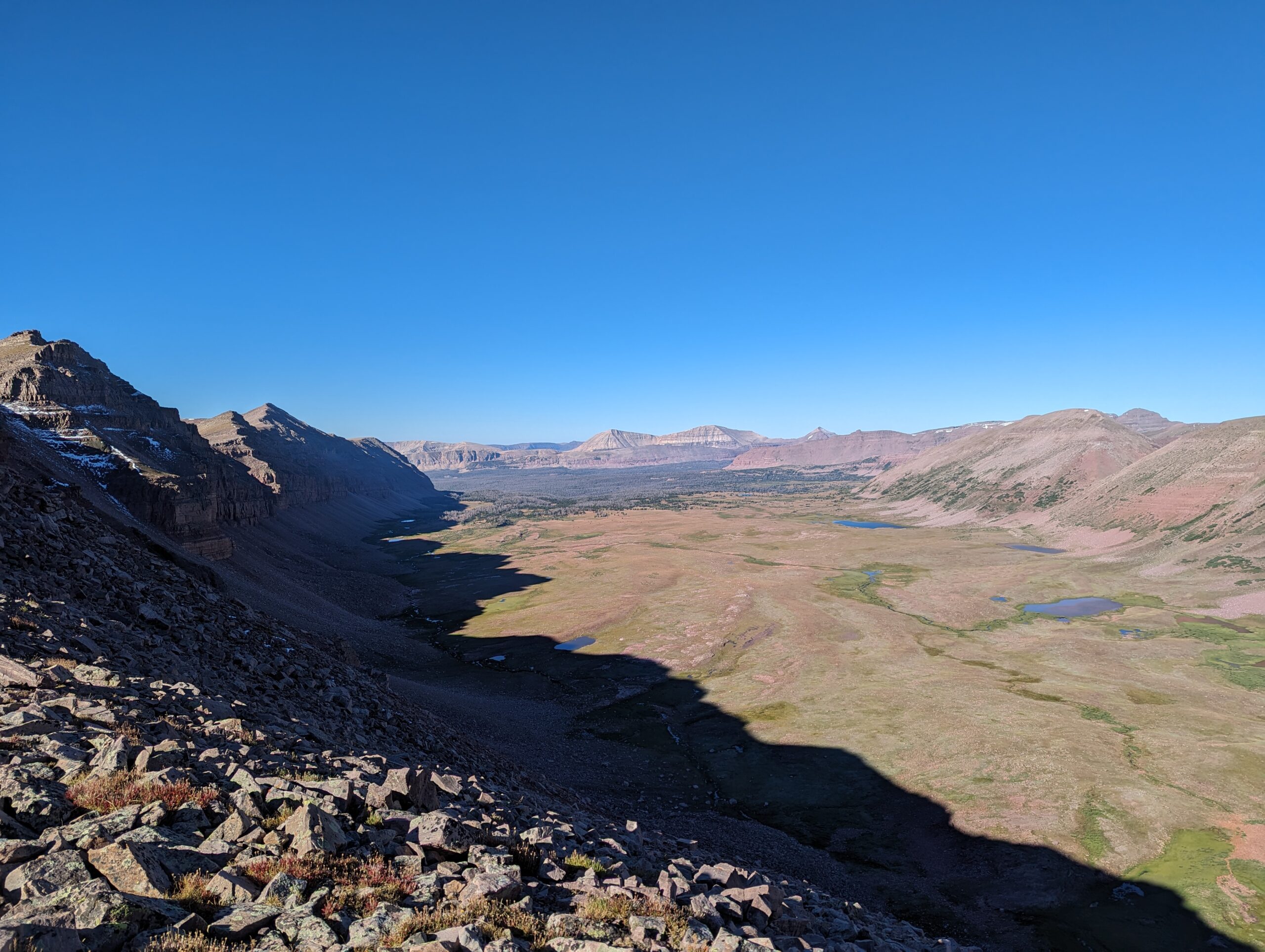
As I hiked through Garfield Basin towards Porcupine Pass, numerous lakes could be seen over rises and in small depressions throughout the basin. Most of the lakes in the high Uintas are unnamed, seemingly because there are so many of them. In this basin alone I could see at least two dozen lakes of varying size and shape, all beckoning for closer examination.
The climb up to Porcupine Pass from Garfield Basin was pretty easy compared to the last few passes, only an 800-foot climb with easy switchbacks up through a talus field. A few small patches of snow lingered near the top, but unlike on Anderson Pass they did not pose much difficulty. The views from the top of Porcupine Pass were sublime, as good if not better than those from Anderson Pass. Oweep Basin on the west side of Porcupine Pass was flanked by mountains in a palette of colors – red, black, white, and yellow. Many of the peaks had huge sandstone cliffs plummeting down their sides in layers like a staircase. The bottom of the basin was green and filled with a multitude of lakes linked by an intricate network of streams.
The descent from Porcupine Pass was much steeper than the ascent, following a series of tight switchbacks through sheer cliffs. Upon reaching the bottom of the descent, the trail petered out and soon became an off-trail stroll through Oweep Basin following a series of absolutely massive cairns. The terrain was exceedingly easy, the Costco-sized cairns were simple to follow, and the views were constant and mesmerizing, making this one of the most relaxing and contemplative sections of the trail (though “trail” is a bit of a misnomer here).
The maintained trail did eventually return as the path traversed below the shoulders of the red-rock mountains to the north and descended to Lake Fork River. The trail then followed the river up to just below Red Knob Pass, where I camped for the night next to a small tarn.


Day 7 – Lake below Red Knob Pass to Camp near Rock Creek
Mile 81.8 – 94.8
With a little over 20 miles of the trail left, the goal for today was to make it over the next two passes, Red Knob Pass and Dead Horse Pass, and get as close as possible to Rocky Sea Pass (the last pass of the trail) to make for an easy exit the following day.
Red Knob Pass and Dead Horse Pass are two major passes located only about 3 miles apart, meaning they can be easily crossed together in a single day. To summarize, this included an 800-foot climb from my campsite to Red Knob Pass, then a 1,400-foot descent to the West Fork Blacks Fork River (quite the name for a river – it appears the Blacks Fork is a tributary of the Green River), followed by another 1,000-foot climb past Dead Horse Lake to Dead Horse Pass, then finally an 800-foot descent down to Ledge Lake.
The climb up Red Knob Pass was not particularly noteworthy or challenging, but the peaks near the pass – including the titular Red Knob – were indeed composed of red rock. Any lingering snow from the last two days had melted, so that was no longer a factor to consider. The top of Red Knob Pass had a magnificent view of Dead Horse Lake and the surrounding mountains, including Red Knob, Mt. Beulah, Mt. Wasatch, and Dead Horse Peak. These mountains were significantly steeper than those in the previous basins, with sheer cliff walls dropping down to the valley below. The descent from Red Knob Pass was also steep with sections of loose scree.
Dead Horse Lake probably has the best backdrop and greenest water of any of the lakes in the Uintas, making it my favorite lake of the trip. It’s a shame I wasn’t able to camp here, but the mileage each day didn’t quite line up for that. The ascent of Dead Horse Pass from the lake was very steep on a very narrow trail with lots of loose scree and rock above sheer cliffs. Terrain-wise, this was the most dangerous ascent of any of the passes. I would not want to attempt this pass with any type of rain or snow, as it is sketchy enough while dry.
The opposite side of Dead Horse Pass displayed yet another unique basin even more glorious than the one before. This basin was part of the much larger Rock Creek basin, and it was most notable for the expansive ledge system and slick rock plateaus that surrounded the basin like the seats of an amphitheatre. The ledges really reminded me of some of the slickrock features in Zion National Park, while the slabs of rock between the ledges reminded me of the granite slabs in the Sierra. The trail descended from the pass between cliffs and then traversed some of this ledge system before reaching the aptly named Ledge Lake.
From Ledge Lake, the trail enters an extensive burn zone from the 2020 Phinney Lake Fire. From previous trail reports, I had heard that the official UHT route was almost impassable due to the amount of fallen trees and washed out trail. The official trail descends to nearly 9,800′ to cross Rock Creek before ascending to Rocky Sea Pass. Two alternate routes exist – the Head of Rock Creek trail which adds 3-4 miles but stays close to or above treeline, or the Jack and Jill trail, which adds about 1.5 miles and stays close to 10,400′ in the forest. I decided to take the Jack and Jill trail, named for a pair of lakes the trail passes. The Jack and Jill trail was less well designated than the UHT and also had a ton of fallen trees to navigate around. Navigating around fallen trees in a burn zone takes a lot of time and effort, and in many areas the trail disappeared or was covered in heavy debris, so safe to say this section was tedious and not enjoyable.
Upon rejoining the official UHT on the other side of the valley, I found a clearing in which to set up camp. This clearing was one of the few safe campsites in the burn scar, as the center was far enough away from any burnt dead trees (colloquially called widowmakers since they can fall without warning during a windstorm). While setting up camp I met a curious deer that kept trying to approach the clearing as if it lived there. Unsure about whether the deer was interested in something in my pack or perhaps a plant nearby, I did feel kind of bad about disturbing it, but with few other options for camping in the area, I decided to stay put. The deer stopped nosing around after about half an hour, leaving me in peace for the rest of the night.


Day 8 – Camp near Rock Creek to Hayden Pass
Mile 94.8 – 104.6
The final day of my time in the High Uintas once again started just after daybreak with the first vestiges of sunlight illuminating the Rock Creek basin. The fire-scourged trees, while not pretty by themselves, offered better views of the valley and mountains as the trail slowly ascended the shoulder below Rocky Sea Pass.
Some 20 minutes after leaving camp, the trail exited the burn area and returned to a spatter of sparse tree clumps near treeline. As I was rounding a corner in the trail, I heard the eerily beautiful call of elk bugling nearby, piercing the cold morning air, and soon a large herd of elk, perhaps 50-60 individuals, sauntered out of a clump of trees about 300 feet away. In awe, I stood still to avoid spooking the elk while enraptured by the magical display of nature before me. With no one else around, I had this show all to myself. But truthfully, this was just the typical behavior for these elk when given ample space to roam without human interference; it is a powerful reminder of the importance of preserving wilderness, not just for recreation, but for the plants and animals that call these spaces home.
After taking my fill of the local fauna, I cautiously hiked around the remainder of the herd and made my way up Rocky Sea Pass, the final mountain pass of the UHT. The pass is mildly steep on the east side and quite mellow on the west side, quite an easy jaunt up compared to most of the other passes before it. The top of the pass had a brilliant view in both directions as expected, though the west side lacked the feel of the high mountain basins that were common earlier in the trip. Instead, much of the hike from Rocky Sea to the trailhead at Hayden Pass was on rolling hills through thick forest with only occasional views of the surrounding mountains. Not to say that it wasn’t pleasant hiking, as it was, with rushing rivers and a few impressive lakes along the way. But it was clear the trail had left the High Uintas and was heading to more low-lying territory.
As I finished the last few miles of the UHT, returned to my car, and drove out of the mountains (while stopping at some roadside waterfalls along the way), I reflected on this trip in context to the other backpacking trips I had done. And actually, this is a great time to look retrospectively at my Uinta Highline Trail adventure, since this hike predates my John Muir Trail thru-hike, meaning I had less backpacking experience at the time. While the Uintas are not as dramatic or rugged as the Sierra Nevada and lack the vastness of the Colorado Rockies I grew up hiking in, it is undeniable that they have a certain charm that sets them apart from other mountain ranges. The basins are broad, flat, and extremely verdant with infinite lakes. The mountains are seemingly gentle but hide massive, tiered cliff systems that are only noticeable when up close and personal with them. The wildlife is abundant and untamed. This is a range of solitude, grandness, and reflection, and all of these attributes are certainly supported by the conscious decision to make the trail merely a suggestion at times, allowing the hiker to become more engrossed in the nature around them instead of just blindly following a single-track. For these reasons and many more, I find the UHT to be unforgettable and a truly unique backpacking experience.
Happy Trails!


